Rindcalc Documentation
About
Rindcalc is an open source python library built on NumPy and GDAL with the goal of providing seamless raster index calculations and composites of satellite imagery for remote sensing. It looks to fill the gap left by proprietary softwares and open source initiatives alike when it comes to the need to create and process spectral index raster files.
Satellites & Imagery
- Landsat-8
- National Agricultural Imagery Program - NAIP
- Sentinel-2
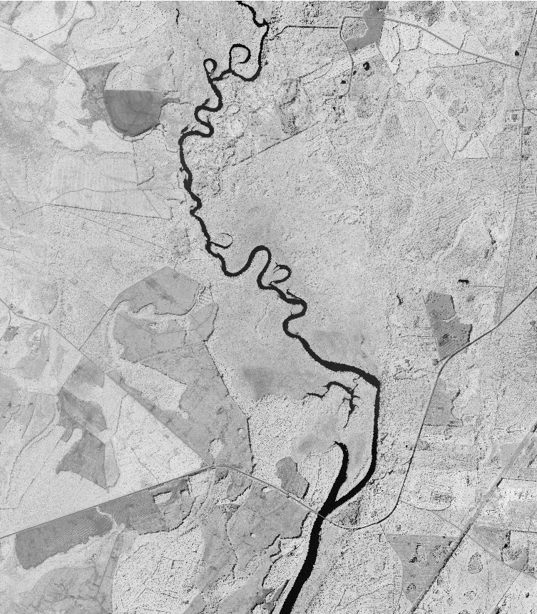
Example of use:
Calculating the ARVI of a NAIP tile and saving as a raster.
import rindcalc as rc
# set inputs and outputs
input_naip = '/naip_folder/m_3008101_ne_17_1_20151017.tif'
output_arvi = '/naip_outputs/ARVI_3008101_ne_17.tif'
data = rc.NAIP(path)
data.ARVI(output_ndvi)
- Output ARVI raster:
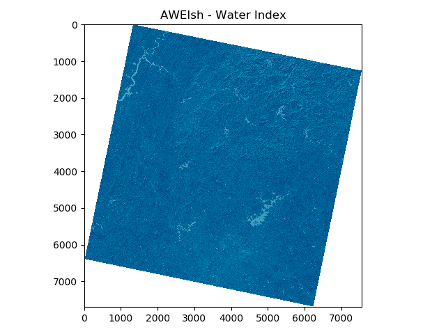
Using in conjunction with matplotlib
from rindcalc import Landsat
import matplotlib.pyplot as plt
ls = '/landsat_8/2019_11_28'
index = Landsat(ls).AWEIsh('/landsat_8/2019_11_28')
plt.imshow(index, 'ocean')
plt.title('AWEIsh - Water Index')
plt.show()
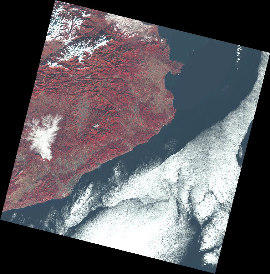
Creating a false color composite of a Landsat-8 Scene.
from rindcalc import Landsat
ls = Landsat('/landsat_8/LC08_L1TP_197031_20131212_20170428_01_T1')
ls.composite(['band_5', 'band_4', 'band_3'], '/landsat_8_outputs/FalseColor_Barcelona.tif')
- Output false color composite:
Install
With pip from PyPI repository
- Dependencies
- GDAL (v 3.0.0 or greater)
- NumPy (v 1.0.0 or greater)
pip install rindcalc
Latest development version
For latest version clone the Rindcalc GitHub Repository and add the module to path with sys.path.append.
Landsat-8
Rindcalc uses the standard naming convention of landsat bands, it only needs the folder in which Landsat-8 bands are contained as the input. This method allows for easy, quick, and consistent index calculations from Landsat-8 imagery.
The Landsat 8 satellite orbits the the Earth in a sun-synchronous, near-polar orbit, at an altitude of 705 km (438 mi), inclined at 98.2 degrees, and circles the Earth every 99 minutes. The satellite has a 16-day repeat cycle with an equatorial crossing time: 10:00 a.m. +/- 15 minutes.
Landsat 8 aquires about 740 scenes a day on the Worldwide Reference System-2 (WRS-2) path/row system, with a swath overlap (or sidelap) varying from 7 percent at the Equator to a maximum of approximately 85 percent at extreme latitudes. The scene size is 185 km x 180 km (114 mi x 112 mi) (USGS).

Landsat-8 scene composite created with rindcalc RGB composite function.
-
class
rindcalc.Landsat(path)¶ -
__init__(path)¶ Class to read and write Landsat-8 data from.
Parameters: path (str) – Path to folder where Landsat-8 bands are contained. -
path¶ Dictionary of the path for each Landsat-8 band.
Type: dict
-
bands¶ Dictionary of arrays for the bands chosen to load.
Type: dict, array
-
band_options¶ List of all options for band input names.
Type: list
-
-
load_bands(which_bands=None)¶ Opens and reads bands into Float 32 arrays. If no list is passed into which bands then all bands are opened and added to the dictionary self.bands.
Parameters: which_bands (list, optional) – A list of band names to open as arrays. e.g. which_bands=[‘band_1’, ‘band_2’, ‘band_3’] Returns: self.bands – Updated self.bands dictionary Return type: dict
-
composite(which_bands, out_composite)¶ Creates a three band composite out of the specified bands.
Parameters: - which_bands (list) – A list of bands to save as a three band composite. Must be in order of how the bands are to saved within the output TIFF. e.g. which_bands=[‘band_1’, ‘band_2’, ‘band_3’]
- out_composite (str) – The output filename to save the composite,
-
NDVI(out_raster=None, mask_clouds=False)¶ Calculates NDVI index
Parameters: - out_raster (str, optional) – Output filepath for calculated TIFF.
- mask_clouds (bool, optional) – Whether or not to apply cloud masking to output index with the QA band.
Returns: equation – Output array of the generated index.
Return type: array
-
AWEIsh(out_raster=None, mask_clouds=False)¶ ” Calculates AWEIsh index
Parameters: - out_raster (str, optional) – Output filepath for calculated TIFF.
- mask_clouds (bool, optional) – Whether or not to apply cloud masking to output index with the QA band.
Returns: equation – Output array of the generated index.
Return type: array
-
AWEInsh(out_raster=None, mask_clouds=False)¶ Calculates AWEInsh index
Parameters: - out_raster (str, optional) – Output filepath for calculated TIFF.
- mask_clouds (bool, optional) – Whether or not to apply cloud masking to output index with the QA band.
Returns: equation – Output array of the generated index.
Return type: array
-
NDMI(out_raster=None, mask_clouds=False)¶ Calculates NDMI index
Parameters: - out_raster (str, optional) – Output filepath for calculated TIFF.
- mask_clouds (bool, optional) – Whether or not to apply cloud masking to output index with the QA band.
Returns: equation – Output array of the generated index.
Return type: array
-
MNDWI(out_raster=None, mask_clouds=False)¶ Calculates MNDWI index
Parameters: - out_raster (str, optional) – Output filepath for calculated TIFF.
- mask_clouds (bool, optional) – Whether or not to apply cloud masking to output index with the QA band.
Returns: equation – Output array of the generated index.
Return type: array
-
GNDVI(out_raster=None, mask_clouds=False)¶ Calculates GNDVI index
Parameters: - out_raster (str, optional) – Output filepath for calculated TIFF.
- mask_clouds (bool, optional) – Whether or not to apply cloud masking to output index with the QA band.
Returns: equation – Output array of the generated index.
Return type: array
-
SAVI(out_raster=None, soil_brightness=0.5, mask_clouds=False)¶ Calculates SAVI index
Parameters: - out_raster (str, optional) – Output filepath for calculated TIFF.
- soil_brightness (float) – Soil brightness factor to compute SAVI with. Defaults to 0.5
- mask_clouds (bool, optional) – Whether or not to apply cloud masking to output index with the QA band.
Returns: equation – Output array of the generated index.
Return type: array
-
ARVI(out_raster=None, mask_clouds=False)¶ Calculates ARVI index
Parameters: - out_raster (str, optional) – Output filepath for calculated TIFF.
- mask_clouds (bool, optional) – Whether or not to apply cloud masking to output index with the QA band.
Returns: equation – Output array of the generated index.
Return type: array
-
VARI(out_raster=None, mask_clouds=False)¶ Calculates VARI index
Parameters: - out_raster (str, optional) – Output filepath for calculated TIFF.
- mask_clouds (bool, optional) – Whether or not to apply cloud masking to output index with the QA band.
Returns: equation – Output array of the generated index.
Return type: array
-
NDBI(out_raster=None, mask_clouds=False)¶ Calculates NDBI index
Parameters: - out_raster (str, optional) – Output filepath for calculated TIFF.
- mask_clouds (bool, optional) – Whether or not to apply cloud masking to output index with the QA band.
Returns: equation – Output array of the generated index.
Return type: array
-
NDBaI(out_raster=None, mask_clouds=False)¶ Calculates NDBaI index
Parameters: - out_raster (str, optional) – Output filepath for calculated TIFF.
- mask_clouds (bool, optional) – Whether or not to apply cloud masking to output index with the QA band.
Returns: equation – Output array of the generated index.
Return type: array
-
NBLI(out_raster=None, mask_clouds=False)¶ Calculates NBLI index
Parameters: - out_raster (str, optional) – Output filepath for calculated TIFF.
- mask_clouds (bool, optional) – Whether or not to apply cloud masking to output index with the QA band.
Returns: equation – Output array of the generated index.
Return type: array
-
EBBI(out_raster=None, mask_clouds=False)¶ Calculates EBBI index
Parameters: - out_raster (str, optional) – Output filepath for calculated TIFF.
- mask_clouds (bool, optional) – Whether or not to apply cloud masking to output index with the QA band.
Returns: equation – Output array of the generated index.
Return type: array
-
UI(out_raster=None, mask_clouds=False)¶ Calculates UI index
Parameters: - out_raster (str, optional) – Output filepath for calculated TIFF.
- mask_clouds (bool, optional) – Whether or not to apply cloud masking to output index with the QA band.
Returns: equation – Output array of the generated index.
Return type: array
-
NBRI(out_raster=None, mask_clouds=False)¶ Calculates NBRI index
Parameters: - out_raster (str, optional) – Output filepath for calculated TIFF.
- mask_clouds (bool, optional) – Whether or not to apply cloud masking to output index with the QA band.
Returns: equation – Output array of the generated index.
Return type: array
-
NAIP
The National Agriculture Imagery Program (NAIP) acquires aerial imagery during the agricultural growing seasons in the continental U.S. A primary goal of the NAIP program is to make digital ortho photography available to governmental agencies and the public within a year of acquisition.
The default spectral resolution is natural color (Red, Green and Blue, or RGB) but beginning in 2007, some states have been delivered with four bands of data: RGB and Near Infrared (USDA).
-
class
rindcalc.NAIP(path)¶ -
__init__(path)¶ Class to read and write NAIP data from.
Parameters: path (str) – Path to folder where Sentinel-2 bands are contained. -
path¶ Dictionary of the path for each Landsat-8 band.
Type: dict
-
bands¶ Dictionary of arrays for the bands chosen to load.
Type: dict, array
-
band_options¶ List of all options for band input names.
Type: list
-
-
load_bands(which_bands=None)¶ Opens and reads bands into Float 32 arrays. If no list is passed into which bands then all bands are opened and added to the dictionary self.bands.
Parameters: which_bands (list, optional) – A list of band names to open as arrays. e.g. which_bands=[‘band_1’, ‘band_2’, ‘band_3’] Returns: self.bands – Updated self.bands dictionary Return type: dict
-
composite(which_bands, out_composite)¶ Creates a three band composite out of the specified bands.
Parameters: - which_bands (list) – A list of bands to save as a three band composite. Must be in order of how the bands are to saved within the output TIFF. e.g. which_bands=[‘band_1’, ‘band_2’, ‘band_3’]
- out_composite (str) – The output filename to save the composite,
-
NDVI(out_raster=None)¶ Calculates NDVI index
Parameters: out_raster (str, optional) – Output filepath for calculated TIFF. Returns: equation – Output array of the generated index. Return type: array
-
ARVI(out_raster=None)¶ Calculates ARVI index
Parameters: out_raster (str, optional) – Output filepath for calculated TIFF. Returns: equation – Output array of the generated index. Return type: array
-
VARI(out_raster=None)¶ Calculates VARI index
Parameters: out_raster (str, optional) – Output filepath for calculated TIFF. Returns: equation – Output array of the generated index. Return type: array
-
SAVI(soil_brightness=0.5, out_raster=None)¶ Calculates SAVI index
Parameters: - soil_brightness (float) – Soil brightness factor to compute SAVI with. Defaults to 0.5
- out_raster (str, optional) – Output filepath for calculated TIFF.
Returns: equation – Output array of the generated index.
Return type: array
-
RedRatio(out_raster=None)¶ Calculates ARVI index
Parameters: out_raster (str, optional) – Output filepath for calculated TIFF. Returns: equation – Output array of the generated index. Return type: array
-
Sentinel-2
“The Copernicus Sentinel-2 mission comprises a constellation of two polar-orbiting satellites placed in the same sun-synchronous orbit, phased at 180° to each other. It aims at monitoring variability in land surface conditions, and its wide swath width (290 km) and high revisit time (10 days at the equator with one satellite, and 5 days with 2 satellites under cloud-free conditions which results in 2-3 days at mid-latitudes) will support monitoring of Earth’s surface changes. The coverage limits are from between latitudes 56° south and 84° north.” - (European Space Agency)
-
class
rindcalc.Sentinel(path)¶ -
__init__(path)¶ Class to read and write Sentinel-2 data from.
Parameters: path (str) – Path to folder where Sentinel-2 bands are contained. -
path¶ Dictionary of the path for each Sentinel-2 band.
Type: dict
-
bands¶ Dictionary of arrays for the bands chosen to load.
Type: dict, array
-
band_options¶ List of all options for band input names.
Type: list
-
-
load_bands(which_bands=None)¶ Opens and reads bands into Float 32 arrays. If no list is passed into which bands then all bands are opened and added to the dictionary self.bands.
Parameters: which_bands (list, optional) – A list of band names to open as arrays. e.g. which_bands=[‘band_1’, ‘band_2’, ‘band_3’] Returns: self.bands – Updated self.bands dictionary Return type: dict
-
composite(which_bands, out_composite)¶ Creates a three band composite out of the specified bands.
Parameters: - which_bands (list) – A list of bands to save as a three band composite. Must be in order of how the bands are to saved within the output TIFF. e.g. which_bands=[‘band_1’, ‘band_2’, ‘band_3’]
- out_composite (str) – The output filename to save the composite,
-
AWEIsh(out_raster=None)¶ Calculates AWEIsh index
Parameters: out_raster (str, optional) – Output filepath for calculated TIFF. Returns: equation – Output array of the generated index. Return type: array
-
NDVI(out_raster=None)¶ Calculates NDVI index
Parameters: out_raster (str, optional) – Output filepath for calculated TIFF. Returns: equation – Output array of the generated index. Return type: array
-
SIPI(out_raster=None)¶ Calculates SIPI index
Parameters: out_raster (str, optional) – Output filepath for calculated TIFF. Returns: equation – Output array of the generated index. Return type: array
-
ARVI(out_raster=None)¶ Calculates ARVI index
Parameters: out_raster (str, optional) – Output filepath for calculated TIFF. Returns: equation – Output array of the generated index. Return type: array
-
NDI45(out_raster=None)¶ Calculates NDI45 index
Parameters: out_raster (str, optional) – Output filepath for calculated TIFF. Returns: equation – Output array of the generated index. Return type: array
-
MTCI(out_raster=None)¶ Calculates MTCI index
Parameters: out_raster (str, optional) – Output filepath for calculated TIFF. Returns: equation – Output array of the generated index. Return type: array
-
MCARI(out_raster=None)¶ Calculates MCARI index
Parameters: out_raster (str, optional) – Output filepath for calculated TIFF. Returns: equation – Output array of the generated index. Return type: array
-
GNDVI(out_raster=None)¶ Calculates GNDVI index
Parameters: out_raster (str, optional) – Output filepath for calculated TIFF. Returns: equation – Output array of the generated index. Return type: array
-
PSSR(out_raster=None)¶ Calculates PSSR index
Parameters: out_raster (str, optional) – Output filepath for calculated TIFF. Returns: equation – Output array of the generated index. Return type: array
-
S2REP(out_raster=None)¶ Calculates S2REP index
Parameters: out_raster (str, optional) – Output filepath for calculated TIFF. Returns: equation – Output array of the generated index. Return type: array
-
IRECI(out_raster=None)¶ Calculates IRECI index
Parameters: out_raster (str, optional) – Output filepath for calculated TIFF. Returns: equation – Output array of the generated index. Return type: array
-
SAVI(soil_moisture=0.5, out_raster=None)¶ Calculates SAVI index
Parameters: - soil_moisture (flt) – Soil moisture value, default = 0.5
- out_raster (str, optional) – Output filepath for calculated TIFF.
Returns: equation – Output array of the generated index.
Return type: array
-
Band Utilities
-
rindcalc.utils.resample.resample(band, cell_size, out=None)¶ Utility function to resample a raster and output it as either an array or TIFF
Parameters: - band (str) – Path to raster file to resample
- cell_size (int) – New size of the cells
- out (str, optional) – Filename to save the output TIFF
Returns: resampled array
-
rindcalc.utils.gen_stats.gen_stats(raster_path)¶ Prints minimum, maximum, mean, median, and standard deviation values for a raster.
Parameters: raster_path (str, required) – input raster with which to generate statistical summary of. Returns: - minimum
- maximum
- mean
- median
- standard deviation
Index Formula List
All index formulas are grouped by specific use here.
Water Indices
Indices designed for water detection
Automated Water Extraction Index | AWEIsh
- For areas with increased shadow.
- AWEIsh = ((Blue + 2.5 * Green - 1.5 * (NIR + SWIR1) - 0.25 * SWIR2)) /
- (Blue + Green + NIR + SWIR1 + SWIR2))
Automated Water Extraction Index | AWEInsh
- For areas with minimal shadow.
- AWEInsh = ((4 * (Green - SWIR1) - (0.25 * NIR + 2.75 *
- SWIR1)) / (Green + SWIR1 + NIR))
Normalized Difference Moisture Index | NDMI
- NDMI = ((NIR - SWIR1) / (NIR + SWIR1))
Modified Normalized Difference Water Index | MNDWI
- MNDWI = ((Green - SWIR1) / (Green + SWIR1))
Vegetation Indices
Indices designed for vegetation detection
Normalized Difference Vegetation Index | NDVI
- NDVI = (NIR - Red) / (NIR + Red)
Green Normalized Difference Vegetation Index | GNDVI
- GNDVI = ( NIR - Green) / ( NIR + Green)
Atmospherically Resistant Vegetation Index | ARVI
- ARVI = (NIR - (2 * Red) + Blue) / (NIR + (2 * Red) + Blue)
Visual Atmospherically Resistant Index | VARI
- VARI = ((Green - Red) / (Green + Red - Blue))
Soil Adjusted Vegetation Index | SAVI
- SAVI = ((NIR - Red) / (NIR + Red + L)) x (1 + L)
- L = Soil Brightness Factor
Structure Insensitive Pigment Index | SIPI
- SIPI = (NIR – Blue) / (NIR – Red)
Urban / Landscape Indices
Indices designed for urban and landscape detection
Normalized Difference Built-up Index | NDBI
- NDBI = (SWIR1 - NIR) / (SWIR1 + NIR)
Nomrmalized Difference Bareness Index | NDBaI
- NDBaI = ((SWIR1 - TIR) / (SWIR1 + TIR))
Normalized Bare Land Index | NBLI
- NBLI = ((Red - TIR) / (Red + TIR))
Enhanced Built-up and Barness Index | EBBI
- EBBI = ((SWIR1 - NIR) / (10 * (np.sqrt(SWIR1 + tir))))
Urban Index | UI
- UI = ((SWIR2 - NIR) / (SWIR2 + NIR))
| Authors: | Owen Smith, University of North Georgia IESA |
|---|---|
| Version: | 2.0.5 |
| License: | GPL v3.0 |